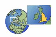
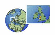
England
England (in Latin, Anglia), country and constituent part of the
island of Great Britain,
comprising, with the principality of Wales, the principal division of the United
Kingdom of Great Britain and Northern Ireland. England occupies all of
the island east of Wales and south of Scotland, another country and division of the United Kingdom. United as an 14414o1423o
independent monarchy in the 10th century, England in time achieved political
control over the rest of the island, all the British
Isles, and vast sections of the world, becoming the nucleus of one of
the largest empires in history. The capital, largest city, and chief port of
England is London, with a population
of 6,967,500 (1994 estimate). It is also the capital of the United Kingdom, and
the site of the headquarters of the Commonwealth of
Nations
England
is very roughly triangular in shape, with its apex at the mouth of the River Tweed on the north-eastern border with Scotland. The
eastern side, bounded by the North Sea, extends generally south-east, via East
Anglia, to the North Foreland in Kent,
the northern extremity of the chalk uplands in south-eastern England called the
Downs. The western side of the triangle extends
generally south-west from the mouth of the Tweed along the border with Scotland,
via the Irish Sea coast, the border with Wales, and the Atlantic Ocean coast to
Land's End, the westernmost extremity
of England and of the island of Great Britain. The northern frontier with
Scotland extends from the Solway Firth in the west along the Cheviot Hills to the mouth of the Tweed on the east. The base of the triangle
fronts the English Channel
and the Strait of Dover
along the south-western and southern coast of England.
The
total area of England is 130,423 sq km (50,356 sq mi), equivalent to 57 per
cent of the area of Great Britain and 54 per cent of the area of the United
Kingdom. This total includes the region of the Scilly
Isles, located south-west of Land's End in the Atlantic Ocean; the Isle of Wight, located off the southern
coast; and the Isle of Man,
located in the Irish Sea between England and Northern
Ireland
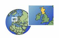
Scotland
Scothland, country,
administrative division of the United Kingdom of Great Britain and Northern Ireland, occupying the northern
third of the island of Great Britain. The crowns of Scotland and England were
united in 1603, and the governments of the two countries in 1707; Scotland has
retained, however, its own legal system, its own Church, a substantially
different education system, and the right to issue its own bank notes. Scotland
is bounded on the north by the Atlantic Ocean; on the east by the North Sea; on
the south-east by England; on the south by the
Solway Firth, which partly separates it
from England, and by the Irish Sea; and on the west by the North Channel of the Irish Sea which separates it from the island of Ireland, and by the Atlantic Ocean. As a geopolitical
entity Scotland includes 186 nearby islands, a majority of which are contained
in three groups-the Hebrides, also known as the
Western Isles, situated off the western coast; the Orkney
Islands, situated off the north-eastern coast; and the Shetland Islands, situated north-east of
the Orkney Islands. The largest of the other islands is Arran, located in the Firth of Clyde, off the west coast. The land area of Scotland, including the
islands, is 77,080 sq km (29,750 sq mi). The country also has some 1,700 sq km
(660 sq mi) of inland water. Edinburgh is the capital of Scotland, and a leading cultural and economic
centre.
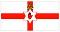
Northern
Ireland
Northern
Ireland, province, integral part of the United Kingdom of Great Britain and Northern Ireland, situated in the
north-eastern portion of the island of Ireland. Northern Ireland is bounded on the north and north-east by the
North Channel, on the south-east by the Irish Sea; on the south and west it has a 488 km (303 mi) border with the Republic of Ireland. It includes Rathlin
Island in the North Channel and several smaller offshore islands.
Northern
Ireland is also known as Ulster, because it comprises six of the nine counties
that constituted the former Irish province of Ulster. The total land area of Northern Ireland is 13,483 sq km (5,206
sq mi). Belfast is the capital of
Northern Ireland.
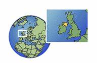
Wales
Wales, country and principality, part of the United
Kingdom of Great Britain and Northern Ireland, united politically,
legally, and administratively with England, and occupying a broad peninsula on
the western side of the island of Great Britain. Wales also includes the island
of Anglesey, which is separated from the mainland by the
narrow Menai Strait. Wales is bounded on the north by the Irish Sea; on the
east by the English counties of Cheshire Shropshire Hereford and Worcester, and Gloucestershire; on the south by the Bristol Channel; and on the west by the St George's Channel and Cardigan
Bay. The maximum north-south length of the Welsh mainland is about
220 km (137 mi); in an east-west direction the width of the country varies
between 60 and 155 km (36 and 96 mi). The total area of Wales is 20,766 sq km
(8,018 sq mi). Cardiff is the capital,
largest city, and principal seaport of Wales.