World Heritage List
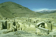
Minaret and Archaeological Remains of Jam
Description
Locations & Maps
Documents
Gallery
Threats
Assistance
|
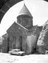
Date of Inscription: 2002 |
Brief Description
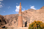
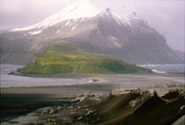
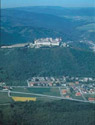
The 65m-tall Minaret of Jam is a graceful, soaring structure, dating back to the 12th century. Covered in elaborate brickwork with a blue tile inscription at the top, it is noteworthy for the quality of its architecture and decoration, which represent the culmination of an architectural and artistic tradition in this region. Its impact is heightened by its dramatic setting, a deep river valley between towering mountains in the heart of the Ghur province.
Justification for Inscription
Criterion (ii): The innovative architecture and decoration of the Minaret of Jam played a significant role in the development of the arts and architecture of the Indian sub-continent and beyond.
Criterion (iii): The Minaret of Jam and its associated archaeological remains constitute exceptional testimony to the power and quality of the Ghurid civilization that dominated its region in the 12th and 13th centuries.
Criterion (iv): The Minaret of Jam is an outstanding example of Islamic architecture and ornamentation in this region and played a significant role in their further dissemination.
Activities
Afghanistan's cultural heritage: Safeguarding Campaign
Coordination Committee
Emergency consolidation and Restoration of Monuments in Herat and Jam, Phase I and II
Emergency consolidation and Restoration of the site of Jam
News
Jul 4, 2006 World Heritage Committee to inscribe new sites on UNESCO's World Heritage List
Jun 26, 2002 World Heritage Committee Inscribes 9 New Sites on the World Heritage List
Events
Apr 10, 2007 - May 7, 2007 Exhibition of photographs: Safeguarding of the Minaret of Jam in Afghanistan
Cultural Landscape and Archaeological Remains of the
Description
Locations & Maps
Documents
Gallery
Threats
|
Date of Inscription: 2003 |
Brief Description
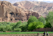
The cultural landscape and archaeological remains of the
Justification for Inscription
Criterion (i): The Buddha statues and the cave
art in
Criterion (ii): The artistic and architectural
remains of
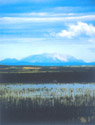
Criterion (iii): The Bamiyan Valley bears an exceptional testimony to a cultural tradition in the Central Asian region, which has disappeared.
Criterion (iv): The Bamiyan Valley is an outstanding example of a cultural landscape which illustrates a significant period in Buddhism.
Criterion (vi): The Bamiyan Valley is the most monumental expression of the western Buddhism. It was an important centre of pilgrimage over many centuries. Due to their symbolic values, the monuments have suffered at different times of their existence, including the deliberate destruction in 2001, which shook the whole world.
Justification for Inscription Document
Activities
Afghanistan's cultural heritage: Safeguarding Campaign
Safeguarding of the Bamiyan site, Phase I
Safeguarding of the Bamiyan Site, Phase II
News
Oct 4, 2007 Terrorist attacks damage Pakistan Buddha
Dec 20, 2005 Fourth Expert Working Group on the Preservation of the Bamiyan Site issued recommendations for Safeguarding Bamiyan
Jun 22, 2001 Twenty-fifth Session of the Bureau of the World Heritage Committee to meet, 25 - 30 june at UNESCO Headquarters, Paris
Events
Dec 14, 2006 - Dec 16, 2006 5th Expert Working Group for the Preservation of the Bamiyan Valley
Dec 7, 2005 - Dec 9, 2005 Fourth Expert Working Group on the preservation of the Bamiyan World Heritage site
Butrint
Description
Locations & Maps
Documents
Gallery
Threats
Assistance
|
Date of Inscription: 1992 |
Brief Description
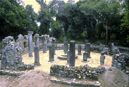
Inhabited since prehistoric times, Butrint has been the site of a Greek colony, a Roman city and a bishopric. Following a period of prosperity under Byzantine administration, then a brief occupation by the Venetians, the city was abandoned in the late Middle Ages after marshes formed in the area. The present archaeological site is a repository of ruins representing each period in the city's development.
News
Dec 19, 2006 The Director-General signs a funds-in-trust agreement for the restoration of the historical centre of Gjirokastra in Albania
Dec 2, 1999 World Heritage Committee Inscribes 48 New Sites on Heritage List
Jun 28, 1997 21st Session of the Bureau of the World Heritage Committee, 23-28 june 1997
Historic Centres of Berat and Gjirokastra
Description
Locations & Maps
Documents
Gallery
Threats
|
Date of Inscription: 2005 |
Brief Description
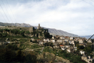
One extension was decided by the Committee, which inscribed the Historic
Centres of Berat and Gjirokastra. This represents the addition of the city
centre of Berat to that of Gjirokastra, which was inscribed in 2005. Berat was
inscribed as a rare example of a well-preserved Ottoman town. Located in
central
News
Jul 8, 2008 Three new sites inscribed on UNESCO's World Heritage List
Jul 8, 2008 Twenty-seven new sites inscribed
Dec 19, 2006 The Director-General signs a funds-in-trust agreement for the restoration of the historical centre of Gjirokastra in Albania
Jul 15, 2005 Mostar, Macao and Biblical vestiges in Israel are among the 17 cultural sites inscribed on UNESCO's World Heritage List
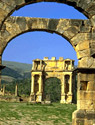
Al Qal'a of
Description
Locations & Maps
Documents
Threats
|
Date of Inscription: 1980 |
Brief Description
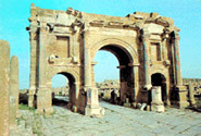
In a mountainous site of extraordinary beauty, the ruins of the first
capital of the Hammadid emirs, founded in 1007 and demolished in 1152, provide
an authentic picture of a fortified Muslim city. The mosque, whose prayer room
has 13 aisles with eight bays, is one of the largest in
Djémila
Description
Locations & Maps
Documents
Threats
|
Date of Inscription: 1982 |
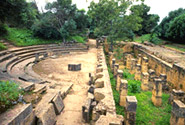
Brief Description
Situated 900 m above sea-level, Djémila, or Cuicul, with its forum, temples, basilicas, triumphal arches and houses, is an interesting example of Roman town planning adapted to a mountain location.
Publications
Ennabli, Abdelmajid. "North Africa's Roman art. Its future" in North Africa's Roman art. Its future , September 2000, pp 18-29
Events
Sep 24, 1997 - Jun 30, 1998 Bikeabout To Launch Circum-Mediterranean Tour Of World Heritage Sites
M'Zab Valley
Description
Locations & Maps
Documents
Gallery
Threats
|
Date of Inscription: 1982 |
Brief Description
A traditional human habitat, created in the 10th century by the Ibadites around their five ksour (fortified cities), has been preserved intact in the M'Zab valley. Simple, functional and perfectly adapted to the environment, the architecture of M'Zab was designed for community living, while respecting the structure of the family. It is a source of inspiration for today's urban planners.
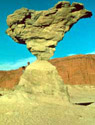
Tassili n'Ajjer
Description
Locations & Maps
Documents
Threats
Assistance
|
Date of Inscription: 1982 |
Brief Description
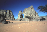
Located in a strange lunar landscape of great geological interest, this
site has one of the most important groupings of prehistoric cave art in the
world. More than 15,000 drawings and engravings record the climatic changes,
the animal migrations and the evolution of human life on the edge of the
Notes
Property inscribed for both geological and ecological values under natural criterion N (ii) before 1994. Criterion N (i) [Operational Guidelines 2002] was added. For more details see Decision 30.COM 8D.1.
Description
Locations & Maps
Documents
Video
Threats
|
Date of Inscription: 1982 |
Brief Description
Publications
Ennabli, Abdelmajid. "North Africa's Roman art. Its future" in North Africa's Roman art. Its future , September 2000, pp 18-29
Tipasa
Description
Locations & Maps
Documents
Gallery
Threats
Assistance
|
Date of Inscription: 1982 |
Brief Description
On the shores of the Mediterranean, Tipasa was an ancient Punic
trading-post conquered by
Publications
Ennabli, Abdelmajid. "North Africa's Roman art. Its future" in North Africa's Roman art. Its future , September 2000, pp 18-29
News
Jul 12, 2006 Giant panda sanctuaries and Tequila-producing area of Mexico among the eight new sites added to World Heritage List
Jul 15, 2002 Tipasa (Algeria) Added to List of World Heritage in Danger
Events
Sep 24, 1997 - Jun 30, 1998 Bikeabout To Launch Circum-Mediterranean Tour Of World Heritage Sites
Kasbah of
Description
Locations & Maps
Documents
Gallery
Threats
Assistance
|
Date of Inscription: 1992 |
Brief Description
The Kasbah is a unique kind of medina, or Islamic city. It stands in one of
the finest coastal sites on the
Events
Sep 24, 1997 - Jun 30, 1998 Bikeabout To Launch Circum-Mediterranean Tour Of World Heritage Sites
Description
Locations & Maps
Documents
Threats
|
Date of Inscription: 2004 |
Brief Description
The cultural landscape of
Justification for Inscription
Criterion (v): The Madriu-Perafita-Claror Valley
is a microcosm of the way its inhabitants have harvested the scarce resources
of the high
News
Jul 13, 2006 World Heritage Committee puts Medieval Monuments in Kosovo on Danger List and extends site in Andorra, ending this year's inscriptions
Los Glaciares
Description
Locations & Maps
Documents
Gallery
Video
Threats
Assistance
|
Date of Inscription: 1981 |
Brief Description

The
Notes
Property inscribed for both geological and ecological values under natural criterion N (ii) before 1994. Criterion N (i) [Operational Guidelines 2002] was added. For more details see Decision 30.COM 8D.1.
Media
![]() NHK World Heritage 100 Series [Windows Media required]
NHK World Heritage 100 Series [Windows Media required]
Jesuit Missions of the Guaranis: San Ignacio Mini, Santa Ana, Nuestra Señora de Loreto and Santa Maria Mayor (Argentina), Ruins of Sao Miguel das Missoes (Brazil)
Description
Locations & Maps
Documents
Threats
|
Date of Inscription: 1983 |
Brief Description
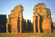
The ruins of São Miguel das Missões in
Description
Locations & Maps
Documents
Gallery
Video
Threats
Assistance
|
Date of Inscription: 1984 |
Brief Description
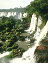
The semicircular waterfall at the heart of this site is some 80 m high and
2,700 m in diameter and is situated on a basaltic line spanning the border
between
Media
![]() NHK World Heritage 100 Series [Windows Media required]
NHK World Heritage 100 Series [Windows Media required]
Activities
The World Heritage Forest Programme
News
Oct 7, 2006 UNESCO and Partners Demonstrate Space Technologies for Monitoring World Heritage
Cueva de las Manos, Río Pinturas
Description
Locations & Maps
Documents
Threats
|
Date of Inscription: 1999 |
Brief Description
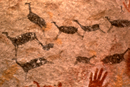
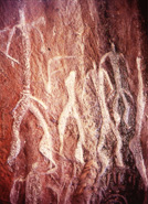
The Cueva de las Manos, Río Pinturas, contains an exceptional assemblage of
cave art, executed between 13,000 and 9,500 years ago. It takes its name (Cave
of the Hands) from the stencilled outlines of human hands in the cave, but
there are also many depictions of animals, such as guanacos (Lama guanicoe),
still commonly found in the region, as well as hunting scenes. The people
responsible for the paintings may have been the ancestors of the historic
hunter-gatherer communities of
Justification for Inscription
Criterion (iii): The Cueva de las Manos
contains an outstanding collection of prehistoric rock art which bears witness
to the culture of the earliest human societies in
News
Dec 2, 1999 World Heritage Committee Inscribes 48 New Sites on Heritage List
Península Valdés
Description
Locations & Maps
Documents
Video
Threats
|
Date of Inscription: 1999 |
Brief Description
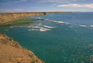
Península Valdés in
Statement of Significance
The World Heritage Committee inscribed Peninsula Valdés on the World Heritage List under criterion (iv).
Peninsula Valdés contains very important and significant natural habitats for the in-situ conservation of several threatened species of outstanding universal value, and specifically its globally important concentration of breeding southern right whales, which is an endangered species. It is also important because of the breeding populations of southern elephant seals and southern sea lions. The area exhibits an exceptional example of adaptation of hunting techniques by the orca to the local coastal conditions.
Media
![]() NHK World Heritage 100 Series [Windows Media required]
NHK World Heritage 100 Series [Windows Media required]
Activities
The Marine Programme: Related World Heritage Properties
News
Dec 2, 1999 World Heritage Committee Inscribes 48 New Sites on Heritage List
Ischigualasto /
Description
Locations & Maps
Documents
Gallery
Threats
|
Date of Inscription: 2000 |
Brief Description
These two contiguous parks, extending over 275,300 ha in the desert region
on the western border of the Sierra Pampeanas of central
Justification for Inscription
Criterion (viii): The site contains a complete sequence of fossiliferous continental sediments representing the entire Triassic Period (45 million years) of geological history. No other place in the world has a fossil record comparable to that of Ischigualasto-Talampaya which reveals the evolution of vertebrate life and the nature of palaeoenvironments in the Triassic Period.
News
Nov 30, 2000 World Heritage Committee Inscribes 61 New Sites on World Heritage List
Jesuit Block and Estancias of Córdoba
Description
Locations & Maps
Documents
Threats
|
Date of Inscription: 2000 |
Brief Description
The Jesuit Block in Córdoba, heart of the former Jesuit Province of Paraguay, contains the core buildings of the Jesuit system: the university, the church and residence of the Society of Jesus, and the college. Along with the five estancias, or farming estates, they contain religious and secular buildings, which illustrate the unique religious, social, and economic experiment carried out in the world for a period of over 150 years in the 17th and 18th centuries.
Justification for Inscription
Criterion (ii): The Jesuit buildings and ensembles
of Córdoba and the estancias are exceptional examples of the fusion of European
and indigenous values and cultures during a seminal period in
Criterion (iv): The religious, social, and
economic experiment carried out in
News
Nov 30, 2000 World Heritage Committee Inscribes 61 New Sites on World Heritage List
Quebrada de Humahuaca
Description
Locations & Maps
Documents
Gallery
Threats
|
Date of Inscription: 2003 |
Brief Description

Quebrada de Humahuaca follows the line of a major cultural route, the
Camino Inca, along the spectacular valley of the
Justification for Inscription
Criterion (ii): The Quebrada de Humahuaca valley has been used over the past 10,000 years as a crucial passage for the transport of people and ideas from the high Andean lands to the plains.
Criteria (iv) and (v): The Quebrada de Humahuaca valley reflects the way its strategic position has engendered settlement, agriculture and trade. Its distinctive pre-Hispanic and pre-Incan settlements, as a group with their associated field systems, form a dramatic addition to the landscape and one that can certainly be called outstanding.
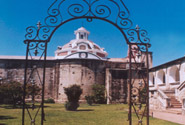
Monasteries of Haghpat and Sanahin
Description
Locations & Maps
Documents
Threats
|
Date of Inscription: 1996 |
Brief Description
These two Byzantine monasteries in the Tumanian region from the period of prosperity during the Kiurikian dynasty (10th to 13th century) were important centres of learning. Sanahin was renown for its school of illuminators and calligraphers. The two monastic complexes represent the highest flowering of Armenian religious architecture, whose unique style developed from a blending of elements of Byzantine ecclesiastical architecture and the traditional vernacular architecture of the Caucasian region.
Justification for Inscription
The Committee decided to inscribe the Monastery of Haghpat on the basis of cultural criteria (ii) and (iv) considering that it is of outstanding universal value and an exceptional example of ecclesiastical architecture that developed in Armenia in the 10th to 13th centuries which is unique by virtue of its blending of elements of both Byzantine church architecture and the traditional vernacular building style of this region.
News
Nov 30, 2000 World Heritage Committee Inscribes 61 New Sites on World Heritage List
Cathedral and Churches of Echmiatsin and the Archaeological Site of Zvartnots
Description
Locations & Maps
Documents
Gallery
Threats
Assistance
|
Date of Inscription: 2000 |
Brief Description
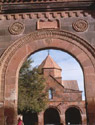
The cathedral and churches of Echmiatsin and the archaeological remains at Zvartnots graphically illustrate the evolution and development of the Armenian central-domed cross-hall type of church, which exerted a profound influence on architectural and artistic development in the region.
Justification for Inscription
Criterion (ii): The developments in ecclesiastical architecture represented in an outstanding manner by the churches at Echmiatsin and the archaeological site of Zvartnots had a profound influence on church design over a wide region.
Criterion (iii): The churches at Echmiatsin and the archaeological site of Zvartnots vividly depict both the spirituality and the innovatory artistic achievement of the Armenian Church from its foundation.
News
Nov 30, 2000 World Heritage Committee Inscribes 61 New Sites on World Heritage List
Links
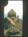
Monastery of Geghard and the
Description
Locations & Maps
Documents
Gallery
Threats
Assistance
|
Date of Inscription: 2000 |
Brief Description
The monastery of Geghard contains a number of churches and tombs, most of
them cut into the rock, which illustrate the very
Justification for Inscription
Criterion (ii): The monastery of Geghard, with its remarkable rock-cut churches and tombs, is an exceptionally well preserved and complete example of medieval Armenian monastic architecture and decorative art, with many innovatory features which had a profound influence on subsequent developments in the region.
Description
Locations & Maps
Documents
Gallery
Threats
|
Date of Inscription: 1981 |
Brief Description

The Great Barrier Reef is a site of remarkable variety and beauty on the
north-east coast of
Activities
The Marine Programme: Related World Heritage Properties
Case Studies on Climate Change and World Heritage
News
Description
Locations & Maps
Documents
Gallery
Threats
|
Date of Inscription: 1981 |
Brief Description

This unique archaeological and ethnological reserve, located in the
Activities
The Marine Programme: Related World Heritage Properties
The World Heritage Forest Programme
News
Jul 12, 1999 In Depth Debate on Kakadu National Park in Extraordinary Session of UNESCO's World Heritage Committee
Sep 18, 1997 Publication Of The Proceedings Of The International Symposium In Hildesheim, Germany: World Cultural Heritage - A Global Challenge
Description
Locations & Maps
Documents
Threats
|
Date of Inscription: 1981 |
Brief Description
The fossil remains of a series of lakes and sand formations that date from the Pleistocene can be found in this region, together with archaeological evidence of human occupation dating from 45-60,000 years ago. It is a unique landmark in the study of human evolution on the Australian continent. Several well-preserved fossils of giant marsupials have also been found here.
Lord Howe Island Group
Description
Locations & Maps
Documents
Gallery
Threats
|
Date of Inscription: 1982 |
Brief Description
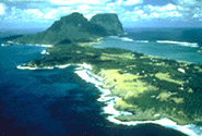
A remarkable example of isolated oceanic islands, born of volcanic activity more than 2,000 m under the sea, these islands boast a spectacular topography and are home to numerous endemic species, especially birds.
Activities
The Marine Programme: Related World Heritage Properties
Tasmanian Wilderness
Description
Locations & Maps
Documents
Gallery
Video
Threats
|
Date of Inscription: 1982 |
Brief Description
In a region that has been subjected to severe glaciation, these parks and reserves, with their steep gorges, covering an area of over 1 million ha, constitute one of the last expanses of temperate rainforest in the world. Remains found in limestone caves attest to the human occupation of the area for more than 20,000 years.
Media
![]() NHK World Heritage 100 Series [Windows Media required]
NHK World Heritage 100 Series [Windows Media required]
Activities
The Marine Programme: Related World Heritage Properties
The World Heritage Forest Programme
Events
Nov 22, 2005 - Dec 2, 2005 UNESCO World Heritage Mentoring Programme for Chinese Experts and World Heritage site managers
Gondwana Rainforests of
Description
Locations & Maps
Documents
Gallery
Threats
|
Date of Inscription: 1986 |
Brief Description

This site, comprising several protected areas, is situated predominantly
along the Great Escarpment on
Notes
Extension of the "Australian
East Coast Temperate and Subtropical
name changed 2007 from 'Central Eastern Rainforest Reserves (
Activities
The World Heritage Forest Programme
Description
Locations & Maps
Documents
Gallery
Threats
|
Date of Inscription: 1987 |
Brief Description
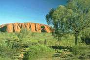
This park, formerly called Uluru (Ayers Rock -
Notes
Renomination of "
Wet Tropics of
Description
Locations & Maps
Documents
Gallery
Threats
|
Date of Inscription: 1988 |
Brief Description

This area, which stretches along the north-east coast of
Activities
The Marine Programme: Related World Heritage Properties
The World Heritage Forest Programme
News
Apr 10, 2007 Climate change threatens UNESCO World Heritage sites
Description
Locations & Maps
Documents
Gallery
Threats
|
Date of Inscription: 1991 |
Brief Description
At the most westerly point of the Australian continent, Shark Bay, with its
islands and the land surrounding it, has three exceptional natural features:
its vast sea-grass beds, which are the largest (4,800 km2) and richest in the
world; its dugong ('sea cow') population; and its stromatolites (colonies of
algae which form hard, dome-shaped deposits and are among the oldest forms of
life on earth).
Activities
The Marine Programme: Related World Heritage Properties
Description
Locations & Maps
Documents
Gallery
Threats
|
Date of Inscription: 1992 |
Brief Description
Activities
The Marine Programme: Related World Heritage Properties
The World Heritage Forest Programme
Australian Fossil Mammal Sites (Riversleigh / Naracoorte)
Description
Locations & Maps
Documents
Gallery
Threats
|
Date of Inscription: 1994 |
Brief Description
Riversleigh and Naracoorte, situated in the north and south respectively of
eastern
Heard and
Description
Locations & Maps
Documents
Threats
|
Date of Inscription: 1997 |
Brief Description
Heard Island and
Justification for Inscription
The Committee inscribed this property under criteria (viii) and (ix). It noted that this site is the only volcanically active sub-Antarctic island and illustrates ongoing geomorphic processes and glacial dynamics in the coastal and submarine environment and sub-Antarctic flora and fauna, with no record of alien species. The Committee repeated its request by the sixteenth session for further documentation on the marine resources of the site.
Activities
The Marine Programme: Related World Heritage Properties
News
Dec 7, 1997 World Heritage Committee Inscribes 46 New Sites on World Heritage List
Description
Locations & Maps
Documents
Gallery
Threats
|
Date of Inscription: 1997 |
Brief Description

Macquarie Island (34 km long x 5 km wide) is an oceanic island in the Southern Ocean, lying 1,500 km south-east of Tasmania and approximately halfway between Australia and the Antarctic continent. The island is the exposed crest of the undersea Macquarie Ridge, raised to its present position where the Indo-Australian tectonic plate meets the Pacific plate. It is a site of major geoconservation significance, being the only place on earth where rocks from the earth's mantle (6 km below the ocean floor) are being actively exposed above sea-level. These unique exposures include excellent examples of pillow basalts and other extrusive rocks.
Justification for Inscription
The Committee decided that the site provides an unique example of exposure of the ocean crust above the sea level and of geological evidence for sea-floor spreading, and is an exposure of the oceanic plate boundary between the Pacific and Australian/Indian plates, exposed with active faults and ongoing tectonic movements.
Activities
The Marine Programme: Related World Heritage Properties
News
Jun 8, 2007 Agreement to Eradicate Rabbits on Macquarie Island
Dec 7, 1997 World Heritage Committee Inscribes 46 New Sites on World Heritage List
Greater
Description
Locations & Maps
Documents
Gallery
Threats
|
Date of Inscription: 2000 |
Brief Description

The Greater Blue Mountains Area consists of 1.03 million ha of sandstone
plateaux, escarpments and gorges dominated by temperate eucalypt forest. The
site, comprised of eight protected areas, is noted for its representation of
the evolutionary adaptation and diversification of the eucalypts in
post-Gondwana isolation on the Australian continent. Ninety-one eucalypt taxa
occur within the Greater Blue Mountains Area which is also outstanding for its
exceptional expression of the structural and ecological diversity of the
eucalypts associated with its wide range of habitats. The site provides
significant representation of
Statement of Significance
The World Heritage Committee inscribed the Greater Blue Mountains Area under natural criteria (ii) and (iv).
Criteria (ii) and (iv):
News
Apr 10, 2007 Climate change threatens UNESCO World Heritage sites
Nov 30, 2000 World Heritage Committee Inscribes 61 New Sites on World Heritage List
Description
Locations & Maps
Documents
Gallery
Threats
|
Date of Inscription: 2003 |
Brief Description
The 239,723 ha
Justification for Inscription
Criterion (viii): Earth's history and
geological features The claim to outstanding universal geological value is made
for the
Criterion (vii): Superlative natural
phenomena or natural beauty and aesthetic importance Although PNP has been
widely known in Australia only during the past 20 years and it remains
relatively inaccessible, it has become recognised internationally for its
exceptional natural beauty. The prime scenic attraction is the extraordinary
array of banded, beehive-shaped cone towers comprising the
Description
Locations & Maps
Documents
Threats
|
Date of Inscription: 2004 |
Brief Description

The
Justification for Inscription
Criterion (ii): The Royal Exhibition Building and
the surrounding
Links
Description
Locations & Maps
Documents
Gallery
Threats
|
Date of Inscription: 2007 |
Brief Description

Inaugurated in 1973, the Sydney Opera House is a great architectural work
of the 20th century that brings together multiple strands of creativity and
innovation in both architectural form and structural design. A great urban
sculpture set in a remarkable waterscape, at the tip of a peninsula projecting
into
Outstanding Universal Value
The Sydney Opera House constitutes a masterpiece of 20th century
architecture. Its significance is based on its unparalleled design and
construction; its exceptional engineering achievements and technological
innovation and its position as a world-famous icon of architecture. It is a
daring and visionary experiment that has had an enduring influence on the
emergent architecture of the late 20th century. Utzon's original design concept
and his unique approach to building gave impetus to a collective creativity of
architects, engineers and builders. Ove Arup's engineering achievements helped
make Utzon's vision a reality. The design represents an extraordinary
interpretation and response to the setting in
Criterion (i): The Sydney Opera House is a great architectural work of the 20th century. It represents multiple strands of creativity, both in architectural form and structural design, a great urban sculpture carefully set in a remarkable waterscape and a world famous iconic building.
All elements necessary to express the values of the Sydney Opera House are included within the boundaries of the nominated area and buffer zone. This ensures the complete representation of its significance as an architectural object of great beauty in its waterscape setting. The Sydney Opera House continues to perform its function as a world-class performing arts centre. The Conservation Plan specifies the need to balance the roles of the building as an architectural monument and as a state of the art performing centre, thus retaining its authenticity of use and function. Attention given to retaining the building's authenticity culminated with the Conservation Plan and the Utzon Design Principles.
The Sydney Opera House was included in the National Heritage List in 2005 under the Environment Protection and Biodiversity Conservation Act 1999 and on the State Heritage Register of New South Wales in 2003 under the Heritage Act 1977. Listing in the National Heritage List implies that any proposed action to be taken inside or outside the boundaries of a National Heritage place or a World Heritage property that may have a significant impact on the heritage values is prohibited without the approval of the Minister for the Environment and Heritage. A buffer zone has been established.
The present state of conservation is very good. The property is maintained and preserved through regular and rigorous repair and conservation programmes. The management system of the Sydney Opera House takes into account a wide range of measures provided under planning and heritage legislation and policies of both the Australian Government and the New South Wales Government. The Management Plan for the Sydney Opera House, the Conservation Plan and the Utzon Design Principles together provide the policy framework for the conservation and management of the Sydney Opera House.
News
Jun 29, 2007 Twenty-two new sites inscribed on UNESCO's World Heritage List, and one deleted during Committee meeting in Christchurch
Jun 28, 2007 World Heritage Committee inscribes four new cultural sites on UNESCO's World Heritage List
Historic Centre of the City of
Description
Locations & Maps
Documents
Gallery
Threats
|
Date of Inscription: 1996 |
Brief Description
Justification for Inscription
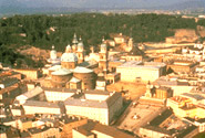
The Committee decided to inscribe the nominated property on the basis of cultural criteria (ii), (iv) and (vi) and considered that the site is of outstanding universal value being an important example of a European ecclesiastical city- state which preserves to a remarkable degree its dramatic townscape, its historically significant urban fabric and a large number of outstanding ecclesiastical and secular buildings from several centuries. It is also noteworthy for its associations with the arts, and in particular with music in the person of its famous son, Wolfgang Amadeus Mozart.
News
Aug 20, 2002 Message on the Occasion of the Floods Affecting a Number of UNESCO World Heritage Sites
Palace and Gardens of Schönbrunn
Description
Locations & Maps
Documents
Video
Threats
|
Date of Inscription: 1996 |
Brief Description
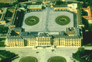
From the 18th century to 1918, Schönbrunn was the residence of the Habsburg emperors. It was designed by the architects Johann Bernhard Fischer von Erlach and Nicolaus Pacassi and is full of outstanding examples of decorative art. Together with its gardens, the site of the world's first zoo in 1752, it is a remarkable Baroque ensemble and a perfect example of Gesamtkunstwerk.
Justification for Inscription
The Committee decided to inscribe the nominated property as an ensemble on the basis of cultural criteria (i) and (iv) considering that the site is of outstanding universal value being an especially well preserved example of the Baroque princely residential ensemble, which constitutes an outstanding example of a Gesamtkunstwerk. The Palace and Gardens are exceptional by virtue of the evidence that they preserve of modifications over several centuries that vividly illustrate the tastes, interests and aspirations of successive Habsburg monarchs.
Media
![]() NHK World Heritage 100 Series [Windows Media required]
NHK World Heritage 100 Series [Windows Media required]
Hallstatt-Dachstein / Salzkammergut Cultural Landscape
Description
Locations & Maps
Documents
Gallery
Video
Threats
|
Date of Inscription: 1997 |
Brief Description

Human activity in the magnificent natural landscape of the Salzkammergut began in prehistoric times, with the salt deposits being exploited as early as the 2nd millennium BC. This resource formed the basis of the area's prosperity up to the middle of the 20th century, a prosperity that is reflected in the fine architecture of the town of Hallstatt.
Justification for Inscription
The Committee decided to inscribe this site on the basis of criteria (iii) and (iv), considering that the Hallstatt-Dachstein/Salzkammergut alpine region is an outstanding example of a natural landscape of great beauty and scientific interest which also contains evidence of a fundamental human economic activity, the whole integrated in a harmonious and mutually beneficial manner.
Media
![]() NHK World Heritage 100 Series [Windows Media required]
NHK World Heritage 100 Series [Windows Media required]
News
Dec 7, 1997 World Heritage Committee Inscribes 46 New Sites on World Heritage List
Semmering Railway
Description
Locations & Maps
Documents
Threats
|
Date of Inscription: 1998 |
Brief Description

The Semmering Railway, built over 41 km of high mountains between 1848 and 1854, is one of the greatest feats of civil engineering from this pioneering phase of railway building. The high standard of the tunnels, viaducts and other works has ensured the continuous use of the line up to the present day. It runs through a spectacular mountain landscape and there are many fine buildings designed for leisure activities along the way, built when the area was opened up due to the advent of the railway.
Justification for Inscription
Criterion (ii): The Semmering Railway represents an outstanding technological solution to a major physical problem in the construction of early railways.
Criterion (iv): With the construction of the Semmering Railway, areas of great natural beauty became more easily accessible and as a result these were developed for residential and recreational use, creating a new form of cultural landscape.
City of
Description
Locations & Maps
Documents
Threats
|
Date of Inscription: 1999 |
Brief Description

Justification for Inscription
Criterion (ii): The historic centre of the city of
Criterion (iv): The urban complex forming the
historic centre of the city of
Wachau Cultural Landscape
Description
Locations & Maps
Documents
Threats
|
Date of Inscription: 2000 |
Brief Description
The Wachau is a stretch of the
Justification for Inscription
Criterion (ii): The Wachau is an outstanding example of a riverine landscape bordered by mountains in which material evidence of its long historical evolution has survived to a remarkable degree.
Criterion (iv): The architecture, the human settlements, and the agricultural use of the land in the Wachau vividly illustrate a basically medieval landscape which has evolved organically and harmoniously over time.
News
Aug 20, 2002 Message on the Occasion of the Floods Affecting a Number of UNESCO World Heritage Sites
Nov 30, 2000 World Heritage Committee Inscribes 61 New Sites on World Heritage List
Fertö / Neusiedlersee Cultural Landscape
Description
Locations & Maps
Documents
Threats
|
Date of Inscription: 2001 |
Brief Description
The Fertö/Neusiedler Lake area has been the meeting place of different cultures for eight millennia. This is graphically demonstrated by its varied landscape, the result of an evolutionary symbiosis between human activity and the physical environment. The remarkable rural architecture of the villages surrounding the lake and several 18th- and 19th-century palaces adds to the area's considerable cultural interest.
Justification for Inscription
Criterion (v): The Fertö-Neusiedler Lake has been the meeting place of different cultures for eight millennia, and this is graphically demonstrated by its varied landscape, the result of an evolutionary and symbiotic process of human interaction with the physical environment.
News
Dec 13, 2001 World Heritage Committee Inscribes 31 New Sites on the World Heritage List
Historic Centre of
Description
Locations & Maps
Documents
Gallery
Threats
|
Date of Inscription: 2001 |
Brief Description

Justification for Inscription
Criterion (ii): The urban and architectural qualities of the Historic Centre of Vienna bear outstanding witness to a continuing interchange of values throughout the second millennium.
Criterion (iv): Three key periods of European cultural and political development - the Middle Ages, the Baroque period, and the Gründerzeit - are exceptionally well illustrated by the urban and architectural heritage of the Historic Centre of Vienna.
Criterion (vi): Since the 16th century
News
Aug 20, 2002 Message on the Occasion of the Floods Affecting a Number of UNESCO World Heritage Sites
Dec 13, 2001 World Heritage Committee Inscribes 31 New Sites on the World Heritage List
Walled City of
Description
Locations & Maps
Documents
Gallery
Threats
Assistance
|
Date of Inscription: 2000 |
Brief Description
Built on a site inhabited since the Palaeolithic period, the Walled City of
Baku reveals evidence of Zoroastrian, Sasanian, Arabic, Persian, Shirvani,
Ottoman, and Russian presence in cultural continuity. The Inner City (Icheri
Sheher) has preserved much of its 12th-century defensive walls. The
12th-century
Justification for Inscription
Criterion (iv): The Walled City of Baku represents an outstanding and rare example of an historic urban ensemble and architecture with influence from Zoroastrian, Sassanian, Arabic, Persian, Shirvani, Ottoman, and Russian cultures.
Gobustan Rock Art Cultural Landscape
Description
Locations & Maps
Documents
Gallery
Threats
|
Date of Inscription: 2007 |
Brief Description
Gobustan Rock Art Cultural Landscape covers three areas of a plateau of
rocky boulders rising out of the semi-desert of central
Outstanding Universal Value
Gobustan has outstanding universal value for the quality and density of its rock art engravings, for the substantial evidence the collection of rock art images presents for hunting, fauna, flora and lifestyles in pre-historic times and for the cultural continuity between prehistoric and mediaeval times that the site reflects.
Criterion (iii): The rock engravings are an exceptional testimony to a way of life that has disappeared in the way they represent so graphically activities connected with hunting and fishing at a time when the climate and vegetation of the area were warmer and wetter than today.
The most remote and undisturbed landscapes are the Jinghirdag
Moutain-Yazylytepe hill and
The knowledge of the site does not extend evenly across the whole rock art reservation. It would be desirable for a large-scale survey of the wider environment to be carried out to ensure the extent of protection needed to ensure the overall integrity of the rock art corpus.
The legal protective measures for the property are adequate. There is a need to complete the documentation, put in place active conservation measures and improve the technical competence of staff to carry out necessary urgent conservation work.
Qal'at al-Bahrain -
Description
Locations & Maps
Documents
Threats
|
Date of Inscription: 2005 |
Brief Description
Qal'at al-Bahrain is a typical tell - an artificial mound created by many successive layers of human occupation. The strata of the 300 × 600 m tell testify to continuous human presence from about 2300 BC to the 16th century AD. About 25% of the site has been excavated, revealing structures of different types: residential, public, commercial, religious and military. They testify to the importance of the site, a trading port, over the centuries. On the top of the 12 m mound there is the impressive Portuguese fort, which gave the whole site its name, qal'a (fort). The site was the capital of the Dilmun, one of the most important ancient civilizations of the region. It contains the richest remains inventoried of this civilization, which was hitherto only known from written Sumerian references.
Justification for Inscription
Criterion (ii): Being an important port city, where people and traditions from different parts of the then known world met, lived and practiced their commercial activities, makes the place a real meeting point of cultures - all reflected in its architecture and development. Being in addition, invaded and occupied for long periods, by most of the great powers and empires, leaved their cultural traces in different strata of the tell.
Criterion (iii): The site was the capital of one of the most important ancient civilizations of the region - the Dilmun civilization. As such this site is the best representative of this culture.
Criterion (iv): The palaces of Dilmun are unique examples of public architecture of this culture, which had an impact on architecture in general in the region. The different fortifications are the best examples of defence works from the 3rd century B.C to the 16th century AD, all on one site. The protected palm groves surrounding the site are an illustration of the typical landscape and agriculture of the region, since the 3rd century BC.
Description
Locations & Maps
Documents
Threats
|
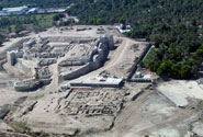
Date of Inscription: 1985 |
Brief Description
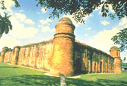
Situated in the suburbs of Bagerhat, at the meeting-point of the Ganges and
Ruins of the Buddhist Vihara at Paharpur
Description
Locations & Maps
Documents
Threats
Assistance
|
Date of Inscription: 1985 |
Brief Description
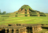
Evidence of the rise of Mahayana Buddhism in
The Sundarbans
Description
Locations & Maps
Documents
Threats
Assistance
|
Date of Inscription: 1997 |
Brief Description
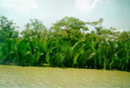
The Sundarbans mangrove forest, one of the largest such forests in the
world (140,000 ha), lies on the delta of the Ganges, Brahmaputra and Meghna
rivers on the
Justification for Inscription
The Committee inscribed the site under criteria (ix) and (x) as one of the largest remaining areas of mangroves in the world, which supports an exceptional biodiversity with a wide range of flora and fauna, including the Bengal Tiger and provides a significant example of on-going ecological processes (monsoon rains, flooding, delta formation, tidal influence and plant colonisation).
Activities
The World Heritage Forest Programme
News
Dec 7, 2007 Sundarbans World Heritage site devastated by cyclone, according to UNESCO experts who visited the site
Apr 10, 2007 Climate change threatens UNESCO World Heritage sites
Dec 7, 1997 World Heritage Committee Inscribes 46 New Sites on World Heritage List
Belovezhskaya Pushcha /
Description
Locations & Maps
Documents
Gallery
Threats
|
Date of Inscription: 1979 |
Brief Description

Situated on the watershed of the Baltic Sea and the
Activities
The World Heritage Forest Programme
Description
Locations & Maps
Documents
Threats
|
Date of Inscription: 2000 |
Brief Description
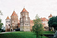
The construction of this castle began at the end of the 15th century, in Gothic style. It was subsequently extended and reconstructed, first in the Renaissance and then in the Baroque style. After being abandoned for nearly a century and suffering severe damage during the Napoleonic period, the castle was restored at the end of the 19th century, with the addition of a number of other elements and the landscaping of the surrounding area as a park. Its present form is graphic testimony to its often turbulent history.
Justification for Inscription
Criterion ii:
Criterion iv: The region in which
Architectural, Residential and Cultural Complex of the Radziwill Family at Nesvizh
Description
Locations & Maps
Documents
Threats
|
Date of Inscription: 2005 |
Brief Description

The Architectural, Residential and Cultural Complex of the Radziwill Family
at Nesvizh is located in central
Justification for Inscription
Criterion (ii): The architectural,
residential and cultural complex of the Radziwill family at Nesvizh was the
cradle for inoculation of new concepts based on the synthesis of the Western
traditions, leading to the establishment of a new architectural school in
Criterion (iv): The Radziwill complex
represents an important stage in the development of building typology in the
history of architecture of the
Criterion (vi): The Radziwill family
was particularly significant for being associated with the interpretation of
the influences from Southern and Western Europe and the transmission of the
ideas in the Central and
News
Jul 15, 2005 Mostar, Macao and Biblical vestiges in Israel are among the 17 cultural sites inscribed on UNESCO's World Heritage List
Struve Geodetic Arc
Description
Locations & Maps
Documents
Gallery
Threats
|
Date of Inscription: 2005 |
Brief Description
The Struve Arc is a chain of survey triangulations stretching from
Justification for Inscription
Criterion (ii): The first accurate measuring of a long segment of a meridian, helping in the establishment of the exact size and shape of the world exhibits an important step in the development of earth sciences. It is also an extraordinary example for interchange of human values in the form of scientific collaboration among scientists from different countries. It is at the same time an example for collaboration between monarchs of different powers, for a scientific cause.
Criterion (iv): The Struve Geodetic Arc is undoubtedly an outstanding example of technological ensemble - presenting the triangulation points of the measuring of the meridian, being the non movable and non tangible part of the measuring technology.
Criterion (vi): The measuring of the arc and its results are directly associated with men wondering about his world, its shape and size. It is linked with Sir Isaac Newton's theory that the world is not an exact sphere.
News
Jul 15, 2005 Mostar, Macao and Biblical vestiges in Israel are among the 17 cultural sites inscribed on UNESCO's World Heritage List
Events
Jul 8, 2006 - Jul 16, 2006 30th Ordinary Session of the World Heritage Committee
|