Digital FEM Height Reference Surface (DFHRS)

The concept and realization of the Digitale Finite Element Model Height Reference Surface (DFHRS) provides in GNSS the direct online conversion of ellipsoidal heights h into standard heights H referring to the height reference surface (HRS), of orthometric, normal-orthometric or normal height systems (Fig 1).
Classical Geoid models, that deliver the geoid height NG(B,L), cannot be used directly, so the well known formula
|
|
does not hold. Identical points are needed to be measured in a field calibration, to solve the unknown parameters d of the geoid-datum N(d) and a scale term Dm between the different height systems h and H. That leeds to the expression
|
|
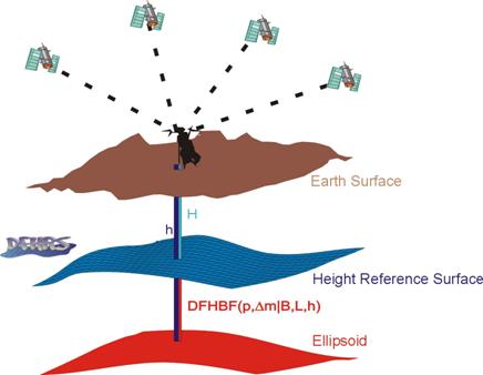
Fig. 1: Sceme of the different Height Sy 414n1320e stems
DFHRS-concept however provides a total 3D DFHRS-correction DFHRS(p,Dm|B,L,h) to convert the ellipsoidal GPS height h directly to the standard height H (fig. 1.) With respect to (2) the so-called 2D "geoid-part" of the DFHRS-correction, which is described as Digital Finite Element Model of the Height Reference Surface (DFHRS) called NFEM(p|B,L), takes over the part (NG(B,L) + N(d)). The additional so-called 1D scale correction Dm h (2) is the second essential part of the total 3D DFHRS-correction DFHRS(p,Dm|B,L,h).
The DFHRS is modelled in its geoid-part as a continuous HRS in arbitrary large areas by bivariate polynomials with parameters p over an irregular grid of the respective Finite Element Model (FEM) meshes. Geoid information (geoid heights NG, vertical deflections x h), gravity anomalies Dg and identical points (h, H) are to be used as observations in a least squares DFHRS computation. It can be shown that the correlated geoid heights NG of a geoid model (e.g. EGM96, EGG97) provide the same DFHRS parameters, than the introduction of the original gravity anomalies Dg used for the evaluation of NG. Several geoid models may be introduced simultaneously, and geoid models may be parted into different "geoid-patches" with individual datum-parameters to reduce the effect of different long-waved systematic errors. Additionally a scale Dm between the height systems h and H is an essential part of lesst squares DFHRS parameter estimation. So the resulting DFHRS represents the HRS in the correct datum, and provides by the 3-dimensional DFHRS-correction DFHRS(p,Dm|B,L,h) - which depends both on plan position (B,L) and the height h - the direct transformation of an ellipsoidal GNNS height h into the standard height H. The complete 3D DFHRS-correction consists of two different parts.
|
|
(3a) (3b) (3c) |
The first correction is the FEM of the HRS, described as a 2D function of the plan position (B,L) by the formula abbreviation NFEM(p|B,L). This correction is accordingly called "geoid-part". The second correction, described as a 1D function of the height h, and appearing as Dm h, is accordingly called "scale-part". Proceeding scientific work and examples have been presented on symposia of FIG Commission 5, IAG and IAG Subcommission for Europe (EUREF). The DFHRS concept has also been proposed as a potential and flexible candidate for the evaluation of the DFHRS for Europe (EU_DFHRS) for the GNSS user community. Meanwhile DFHRS data bases have become official products in different countries and the DFHRS data base access is provided by different receiver manufacturers. The accuracy of the DFHRS is controlled by the mesh size, and a one-cm accuracy for the online correction DFHRS(p,Dm|B,L,h) is a proved standard, e.g. for SAPOS® DGPS, while also dm ("rapid/light") DFHRS are requested by e.g. GIS/Navigation users.
Dinter, G. and M. Illner (2001): Höhenbestimmung mit GPS am Beispiel von Pilotprojekten aus Baden-Württemberg. DVW Schriftenreihe (41). Wittwer-Verlag. ISBN 3879192766. S. 88 - 110.
Dinter, G.; lllner, M. and R. Jäger (1997): A synergetic approach for the integration of GPS heights into standard height systems and for the quality control and refinement of geoid models. In: Veröffentlichungen der Internationalen Erdmessung der Bayerischen Akademie der Wissenschaften (57). IAG Subcommission for Europe Symposium EUREF, Ankara 1996. Beck'sche Verlagsbuchhandlung, München.
Jäger, R. (1998): Ein Konzept zur selektiven Höhenbestimmung für SAPOS. Beitrag zum 1. SAPOS-Symposium. Hamburg 11./12. Mai 1998. Arbeitsgemeinschaft der Vermessungsverwaltungen der Länder der Bundesrepublik Deutschland (Hrsg.), Amt für Geoinformation und Vermessung, Hamburg. S. 131-142.
Jäger, R. (1999c): State of the art and present developments of a general approach for GPS-based height determination. In (M. Lilje, ed.): Proceedings of the Symposium Geodesy and Surveying in the Future - The importance of Heights, March 15-17, 1999. Gävle/Schweden Reports in Geodesy and Geographical Informations Systems, LMV-Rapport 1999(3). Gävle, Schweden. ISSN 0280-5731: 161-174.
Jäger, R. and S. Leinen (1992): Spectral Analysis of GPS-Networks and Processing Strategies due to Random and Systematic Errors. In: Defense Mapping Agency and Ohio State University (Eds.) Proceedings of the Sixth International Symposium on Satellite Positioning, Columbus/Ohio (USA), 16-20 March. Vol. (2), p. 530-539.
Jäger, R. and S. Schneid (2001a): GPS-Höhenbestimmung mittels Digitaler Finite-Elemente Höhenbezugsfläche (DFHBF) - das Online-Konzept für DGPS-Positionierungsdienste. XI. Internationale Geodätische Woche in Obergurgl/Österreich, Februar 2001. Institutsmitteilungen, Heft Nr. 19, Institut für Geodäsie der Universität Innsbruck: 195-200.
Jäger, R. (2001): Online and Postprocessed GPS-heighting based on the Concept of a Digital Finite Element Height Reference Surface. In: J. Kaminskis and R. Jäger (Eds.): 1st Common Baltic Symposium, GPS-Heighting based on the Concept of a Digital Height Reference Surface (DFHRS) and Related Topics - GPS-Heighting and Nation-wide Permanent GPS Reference Systems Riga, June 11, 2001. In press.
Jäger, R. and S. Schneid (2001b): DFHRS-Homepage: www.DFHBF.de .
Jäger, R. and S. Schneid (2001c): Online and Postprocessed GPS-Heighting based on the Concept of a Digital Height Reference Surface. Contribution to IAG International Symposium on Vertical Reference Systems, February 2001, Cartagena, Columbia. In press.
Jäger, R. and S. Schneid (2001d): Online and Postprocessed GPS-heighting based on the Concept of a Digital Height Reference Surface. In: Veröffentlichungen der Internationalen Erdmessung der Bayerischen Akademie der Wissenschaften (62). IAG Subcommission for Europe Symposium EUREF, Dubrovnik 2001. Beck'sche Verlagsbuchhandlung, München. In press.
Jäger, R. and S. Schneid (2002): Paßpunktfreie direkte Höhenbestimmung mittels Digitaler Finite Elemente Höhenbezugsfläche (DFHBF) - ein Konzept für Positionierungsdienste wie SAPOS®. Beitrag zum 4. SAPOS-Symposium. Mai 2002. Im Druck.
Meichle, H. (2001): Digitale Finite Element Höhenbezugsfläche (DFHBF) für Baden-Württemberg. DVW Mitteilungen , Heft 2. DVW Landesverein Baden-Württemberg. ISSN 0940-2942. S. 23-31.
Schneid, S. (2001): Software Development and DFHRS computations for several countries. J. Kaminskis and R. Jäger (Eds.): 1st Common Baltic Symposium, GPS-Heighting based on the Concept of a Digital Height Reference Surface (DFHRS) and Related Topics - GPS-Heighting and Nation-wide Permanent GPS Reference Systems Riga, June 11, 2001.
|